Did you know that about 75% of the world's population lives within 50km of a coastline, and 90% lives within 10km of fresh water? We rely on water for drinking, transportation, recreation, agriculture, electricity, and many forms of industry. We even use it to flush waste products away.
What's more, we depend on the water levels around us to remain relatively stable. Too high or too low can be catastrophic. That's why water levels are monitored closely by federal, state, and local governments, as well as many private enterprises. Water level monitoring is an essential part of land and habitat management, as well as flood risk management. It plays a role in regional and municipal water management and in many production processes.
Of course, sorting through all the options for measuring water levels can feel overwhelming. This article will provide the foundational understanding you need to make those decisions. These are the questions we'll cover...
- What is water level?
- Why is water level so important?
- What are the different ways to measure water level?
- How do you decide which water level measurement device(s) to use?
What is water level?
Water level is defined as the vertical distance (or elevation) from a specified point of reference to the water's surface. In rivers and streams, it is often referred to as gauge (gage) height or stage.
When defining the water level for surface water, the reference point is typically specified as some point below the water's surface. However, in subsurface water, such as groundwater and tanks, the reference point is more commonly defined as a point above the water's surface.
The level of surface water is closely related, but not necessarily identical to, its depth. In surface water, depth measures the vertical distance from the water's surface to the bottom. For water level measurements, the reference point can be whatever the user defines it to be. This could be the bottom, but it doesn't have to be. If we know the difference between the bottom and the user's selected reference point, we can readily calculate depth from water level.

Why water levels matter
There are many excellent reasons why so many people from so many different walks of life pay so much attention to water levels. Here are just a few of the main ones:
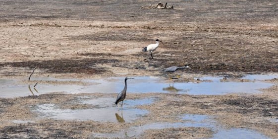
Water levels impact environmental health
When water levels are too high or too low, they can negatively impact the environment. Reduced water levels can result in a loss of habitat for fish and other wildlife, a loss of available food and drinking water for wildlife, higher concentrations of pollutants in the remaining water, and erosion of exposed soils. When water levels become high enough to cause flooding, the resulting floods can erode riverbanks and riverbeds. Those floods can negatively impact water quality by spreading pollutants and silt. And they can damage vegetation.
By understanding the water levels that are needed to maintain the health of a given ecosystem, land managers can take steps such as maintaining levees and spillways to help maintain desired water levels.
Flooding endangers human life and property
Regardless of the exact mechanism, high water levels can result in flooding.
How common is flooding? The National Oceanic and Atmospheric Organization (NOAA) points out, "Flooding occurs in every U.S. state and territory." And the World Bank estimates that about 2.2 billion people or 29% of the world's population lives in areas that have at least a 10% probability of flooding in any given decade.

You might be surprised to learn just how much harm flooding does to lives, property, and infrastructure. The National Weather Service estimates that floods are the second leading cause of fatalities, just after heat. And the Federal Emergency Management Agency (FEMA) has estimated that floods are responsible for about $8.2 billion in damages annually. Yet, that number pales in comparison to the more than $112 billion in damage that Hurricane Ian caused — most of which was due to flooding brought on by the storm surge.
.jpg?width=561&height=280&name=Untitled%20design%20(1).jpg)
By monitoring water levels:
- We can optimize the operation of structures like dams and reservoirs to help mitigate flood risk.
- We can more reliably anticipate floods, allowing more time to put protective measures in place and to move people out of harm's way.
- We can keep people from moving into harm's way by taking measures such as alerting drivers to flooded roadways.
- And, by understanding which areas are most prone to flooding, we can proactively steer settlement and infrastructure development away from those areas that face the greatest flood risks.
Low water levels can disrupt hydroelectric and water supplies
When surface water levels fall too far, reservoirs can become depleted, endangering water supplies and potentially disrupting the production of hydroelectric power by dams.
For example, about 25 million people rely on water from America's largest reservoir, Lake Mead. And more than 1.3 million people rely on hydroelectric power produced by Hoover Dam at Lake Mead. Yet, the water level in Lake Mead has become concerningly low, which could ultimately impact both water and energy supplies.
.jpg?width=561&height=280&name=Untitled%20design%20(2).jpg)
In July 2022, the reservoir's water level fell to 1,040 feet — the lowest level since it was constructed. Even with all the atmospheric rivers in the western U.S. in early 2023, the water level in March 2023 was still 15 feet lower than it was at the same time in 2022. Based on these trends, the reservoir appears to be headed toward deadpool level — the point at which the water level becomes too low to reach the dam intake and support the production of hydroelectric power. That point occurs at about 895 feet. At about 20 feet below that, the reservoir's water level would be too low even to reach its lowest water supply intake — thereby cutting off millions from drinking water.
|
UPDATE As of June 9, 2025, Lake Meade's water level stands at 1,056 feet. Following a general upward trend from March 2023 to March 2024, the lake's water level has been on a declining trajectory. It's winter pool was 915 feet, which is only 20 feet above deadpool. |
By understanding the extent and rate at which water resources are being depleted at reservoirs and dam sites like Lake Mead, resource managers at those locations can implement conservation practices that are most appropriate to their circumstances.
Low water levels can impede shipping
Low water levels can impede river traffic just as easily as flood conditions. And the economic impact can be significant.
We saw this with the Mississippi River in 2022. The river has historically carried about half the cargo tonnage shipped between Louisiana and the 12 states touching the upper Mississippi River system. Then, in October 2022, water levels were recorded at nearly 11 feet below zero-gauge (the reference point from which water levels for the site are calculated). Portions of the river became temporarily impassible. Even when barges could get through, they had to reduce the amount of cargo to compensate for the shallower water. Total economic losses from this event are estimated to be around $20 billion.
.jpg?width=561&height=280&name=Untitled%20design%20(3).jpg)
By monitoring water levels in situations like this, we can at least take steps to mitigate the total losses. Ships and barges can mitigate the risk of bottoming out by rightsizing their cargo weights. Water authorities can limit the movement of river traffic to ensure that ships and barges go only where and when it is safe. And dredging operations can be targeted where they are most needed.
Water level measurement methods
To monitor water levels effectively, we must be able to take accurate and objective measurements. There are several main types of water level measurement devices, also commonly called stream gauges or water level sensors:
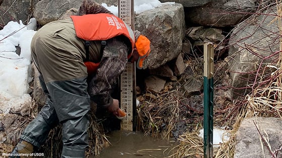
- A staff gauge looks like a yard stick or giant ruler sticking out of the water. Markings on the gauge provide a visual indication of current water level. Although staff gauges can be effective across a wide range of applications, they do have the limitation of not allowing remote readings. Someone must be onsite to observe the gauge and collect readings. They are extremely popular as "reference gauges" for calibrating electronic water level sensors.
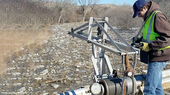
- A wire-weight gauge is made up of a weight attached to a spool of wire. The device is typically attached above the water level to a bridge or other permanent structure. To capture a reading, a technician must unspool the wire until the weight touches the water. Like staff gauges, wire weight gauges require that a technician be present to capture a reading; they do not allow for remote readings. Also, like staff gauges, they are often used as reference gauges for calibrating electronic water level sensors.
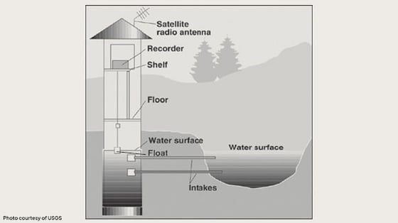
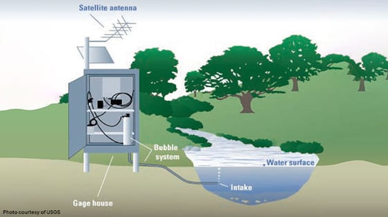
- A shaft encoder is comprised of a float and a counterweight suspended from a pulley mounted on a shaft. As the water level fluctuates, the pulley and shaft rotate. A counter or encoder keeps track of the number of rotations (and their direction) to monitor how far the water level has fallen or risen. Rather than giving an "absolute" water level, a shaft encoder shows changes in water level.
To minimize "noise" in its readings, a shaft encoder must be installed in a stilling well, which is essentially a large hollow tube along the riverbank. An intake allows water from the stream to flow into the stilling well until it reaches the same level as that of the stream, except that the water in the well is "still." When attached to a data logger or transmitter, a shaft encoder can enable remote readings.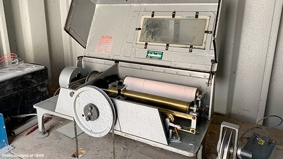
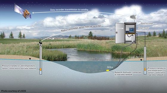
- A pressure transducer features a strain gauge that is sensitive to the amount of pressure being exerted by the water column. When calibrated, that pressure can be converted to a reading of feet or meters. However, water is not the only source of pressure. To compensate for atmospheric pressure, a pressure transducer must be vented to the air above, or it must be used in conjunction with a topside barometer.
Although pressure transducers are relatively inexpensive to install, they can drift or become clogged, which can result in erratic readings. As a result, they require regular inspection and maintenance. It is recommended that pressure transducers be used in conjunction with secondary measurement devices for redundancy.
- A bubbler forces (or bubbles) a gas, such as nitrogen, through an orifice mounted in the stream. The device detects the amount of pressure needed to force the gas into the water. The device must be calibrated to convert that pressure reading into a water level measurement.
Although the orifice line touches the water, the actual sensor is to be mounted safely away from the water, thereby reducing maintenance costs. Although bubblers can supply accurate data across a wide range of conditions, turbulent waters can clog orifice lines or cause drawdown (a condition in which isolated columns of water may be at a lower level than surrounding columns), which can negatively impact data accuracy.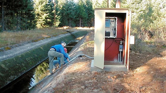
- Radar sensors rely on the same principle as other radar devices. They transmit electromagnetic waves and measure the echoes that are returned to them. When radar is calibrated correctly, those echoes can contain a significant amount of information, including the distance to the water's surface below. That measurement can then be converted into a water level.
To provide accurate readings, the radar should be mounted level, on a stable structure, with an unobstructed view of the water below. It should generally be aimed away from areas that are susceptible to drawdown, since drawdown can introduce readings that do not accurately reflect the surrounding water levels. Windy conditions over low-velocity pools can also interfere with getting accurate readings.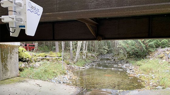
- Hydroacoustic sensors transmit sound through the water and use the Doppler principle to measure a variety of parameters, including water velocities, discharge patterns, flow patterns, current patterns, as well as the surface of the water.
Selecting the right water level sensor(s)
There is no such thing as the best type of water level sensor. But some sensors will be better suited than others to certain applications and/or priorities. To figure out the type of water level sensor that will work best for you, it's important to understand your specific priorities and the circumstances in which your sensor(s) will be deployed.
Here are the main considerations that should factor into your decision-making:
Physical site characteristics
The physical characteristics of your site are among the most important considerations that need to factor into your decision-making. Are you selecting a water level sensor for an ephemeral stream that only flows after precipitation events? Or is if for a high-velocity river that experiences periodic debris flow? Or maybe it's for a reservoir? Each type of site will have different sensor needs.
The table below shows which types of water level sensors are generally preferred across the more common types of deployments.
|
Application |
Preferred device |
2nd choice |
3rd choice |
|
Reservoir |
Shaft encoder | Bubbler |
Pressure transducer |
| Large river (with high velocity & debris flow) | Radar (if mounting structure is available) | Bubbler | |
| Estuary | Hydroacoustic sensors | ||
| Open pool (affected by wind) | Bubbler | Pressure transducer | |
| Ephemeral / intermittent stream | Pressure transducer or radar (if mounting structure is available) | Bubbler | |
| Open channel (with stable control) | Radar | Bubbler | |
| Lake | Hydroacoustic sensors | ||
| Watershed (with shallow depth & rapid stage change) | Pressure transducer | Radar | |
| Bay | Hydroacoustic sensors |
Total deployment cost
Beyond physical site requirements, you also need to consider your budgetary constraints. For example, staff gauges are among the least expensive water level sensors available, but they also have their limitations. In addition, depending on the type of sensor, deployment costs may go well beyond the cost of the actual sensor. For example, to deploy shaft encoders correctly, you also need to invest in the buildout of stilling wells, which can be costly.
Upfront cost vs. operating cost
How does your budget for capital investment compare to your operating budget? For example, pressure transducers can be relatively inexpensive to install, but they need more upkeep than some other sensors. On the other hand, shaft encoders and bubblers may cost more upfront, but their upkeep will generally be more economical on the backend.
Ease of maintenance and worker safety
Non-contact sensors, like radar, can operate without contacting the water. Many clients tend to prefer non-contact sensors for ease of maintenance and the safety of technicians. But only a small fraction of sensor types are non-contact, and they may not be ideal for every application. In addition, they may cost more than some other alternatives.
Data collection and personnel availability
How often do you need to collect readings? Do you have available staff to collect readings as they are needed? Staff gauges and wire-weight gauges require that a technician be onsite to collect readings from them. Most other water level sensors, when coupled with data loggers and proper telemetry, allow readings to be taken remotely.
Data redundancy
Major floods can damage sensors and disrupt the flow of data. There may also be occasional circumstances that prevent a water level sensor from returning accurate data. For example, pressure sensors and bubblers do not produce consistent readings in brackish waters (i.e., a mixture of fresh and salt waters). When placed near the coast, these sensor types may produce erroneous readings when large coastal storms produce storm surges that push salt water into the freshwater system.
To ensure a consistent flow of accurate information, many clients will deploy multiple sensors at a site. If one sensor is damaged during a flood, the other can continue to send data. If two sensors return different data, technicians can investigate the source of the discrepancy and establish which one supplied the correct data. This redundancy can provide clients with greater confidence in the data they are receiving.
Ongoing vs. occasional use
Will you be using the water level sensor continuously throughout the year, or do you only need it to augment your network during significant flood events? A Rapid Deploy Gauge (RDG) can deliver the situational awareness that emergency managers and forecasters need during significant flood events, or it can be temporarily deployed as needed to take the place of a damaged water level sensor. The advantage of RDGs is that they are quick and easy to install for short-term use.
Bringing it together
For an even deeper dive into the best practices for matching the right water level sensor technologies with the right applications, check out our webinar on the topic:
Design your perfect water monitoring solution
Looking for some extra help to develop or expand your water monitoring network? AEM's Hydrologic Network Design Services can help you design and build a network that is ideally suited to your unique needs. Contact us for a free consultation.